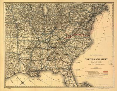
1887 Norfolk and Western Railroad

Map showing the Norfolk & Western Railroad and its connections. G.W. & C.B. Colton & Co. New York, 1887. Map of the eastern United States showing drainage, cities and towns, distance by 100-mile concentric circles centered on Roanoke, and the railroad network with emphasis on the main line. This line became one of the world's greatest coal carriers. It began as the City Point Rail Road from Petersburg to City Point, a distance of 9 miles. It was consolidated in 1870 as the Atlantic, Mississippi, and Ohio Railroad. See entry 491. It was sold in 1881 under the above name. In 1896 it was reorganized as the Norfolk and Western Railway Company.
SKU: trans076
Price Starting At: $12.50