1688 Saxony, Germany
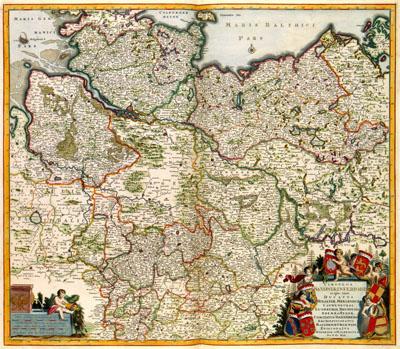
CIRCULIS | SAXIONIAE INFERIORIS | in quo sunt | DUCATUS | HOLSATIAE, MEKLENBURG | LAUWENBURGI, | LUNEBURGI, BRUNSUIGI, | BREMAE et FERDAE, | COMITATUS DANNEBERGI | ARCHIEPISCOPATUS | MAEGDENBURGENSIS, | EPISCOPATUS | HILDESIAE et HALBERSTAD, Frederik de Wit (1688) This map of the southern part of Saxony was published by Frederik de Wit (1630-1706). There is no date on the map, as many maps published by De Wit. For the image of the map, De Wit may have used older Dutch or German sources
SKU: 17thcentury013
Price Starting At: $12.50