1883 Atlantic and Pacific Railroad
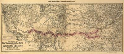
Map showing the new transcontinental route of the Atlantic & Pacific Railroad and its connections. G.W. & C.B. Colton & Co. New York, 1883. Shows relief by hachures, drainage, cities and towns, township lines, the land grant of the "western division," railroads in progress of completion, and completed lines with their connections. At top of map: Extra-Beilag zue New-Yorker Handels-Zeitung. Map covering the southwestern states but extending from Chicago to the Pacific Coast.
SKU: trans053
Price Starting At: $12.50