1879 Cincinnati Southern Railway
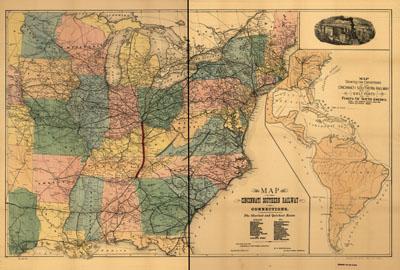
Map of the Cincinnati Southern Railway and connections ... Published for the Cincinnati Southern Railway. Mendenhall, Edward. Cincinnati, 1879. Inset: Map showing the connection of the Cincinnati Southern Railway with the Gulf ports and the ports of South America. Map of the eastern United States showing relief by hachures, drainage, cities and towns, state boundaries, and the railroad network with heavy red and black lines for the main lines. Distances shown by 100-mile concentric circles centered on Cincinnati.
SKU: trans062
Price Starting At: $12.50