1871 Plymouth, Kankakee, and Pacific
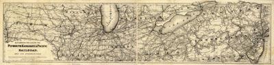
Map showing the line of the Plymouth, Kankakee, & Pacific Railroad and its connections. G.W. & C.B. Colton & Co. New York, 1871.Map of the middle Atlantic and midwestern states showing drainage, cities and towns, township and county boundaries, and the railroad network. This is the Indiana portion of a projected railroad from Plymouth, Ind., on the Pittsburgh, Fort Wayne, and Chicago Railroad, to Bureau Junction, on the Chicago, Rock Island, and Pacific Railroad.
SKU: trans003
Price Starting At: $12.50