1868 Lake Superior to the Pacific Ocean
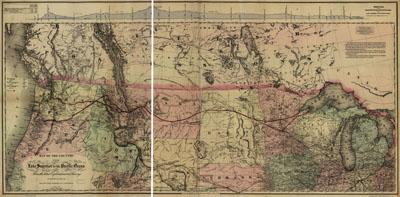
Map of the country from Lake Superior to the Pacific Ocean. From the latest explorations and surveys to accompany the report of the New York Chamber of Commerce, April 1868. G.W. & C.B. Colton & Co. [n.p.], 1867. Indicates railroads in the Great Lakes region, south to the Ohio River, and from New York State to the Mississippi River. Shows proposed railroads as far west as the Missouri River.
SKU: trans068
Price Starting At: $12.50