1868 Columbus, Chicago, Indiana Central
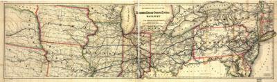
Map showing the lines of the Columbus, Chicago, and Indiana Central Railway, and their connections. G.W. & C.B. Colton & Co. New York, 1868. Township and county map of the middle Atlantic and midwestern states showing drainage, cities and towns, railroad stations, railroads, and distances between stations.
SKU: trans063
Price Starting At: $12.50