1867 Atlantic, Mississippi, and Ohio Railroad
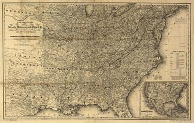
A map showing the Atlantic Mississippi & Ohio R.R. and its connections from Norfolk to Cumberland Gap via Bristol. G.W. & C.B. Colton & Co. New York, 1867 Inset: Plan showing the Atlantic Mississippi & Ohio R.R. as part of the Great Southern R.R. lines from the Atlantic to the Pacific. Map of the eastern half of the United States shows drainage, counties, cities and towns, canals, railroads, and a table of railroad distances
SKU: trans054
Price Starting At: $12.50