1863 Chesapeake Bay
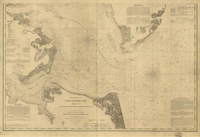
Chesapeake Bay, Sheet no. 1, York River, Hampton Roads, Chesapeake entrance.. From a trigonometrical survey under the direction of A. D. Bache, Superintendent of the survey of the coast of the United States. Triangulation by E. Blunt & J. Farley, Assistants. Topography by J. J. S. Hassler, G. D. Wise, J. Seib, Assts. & J. Mechan, Sub-Asst. Hydrography by the party under the command of Lieut. Comdg. J. J. Almy, U.S.N. Assistant. Redd. drng. by W. M. C. Fairfax, A. Strausz & L. D. Williams. Engd. by J. Knight, A. Sengteller, H. S. Barnard & J. C. Kondrup. At head of title: Coast chart no. 31. Printed in the upper margin: "No. 131" and "Electrotype copy no. 2 by G. Mathiot, U.S.C.S." General chart indicating soundings, lighthouses, buoys, and coastal vegetation. Includes sailing directions. (1863)