1863 Charleston and it's Defenses
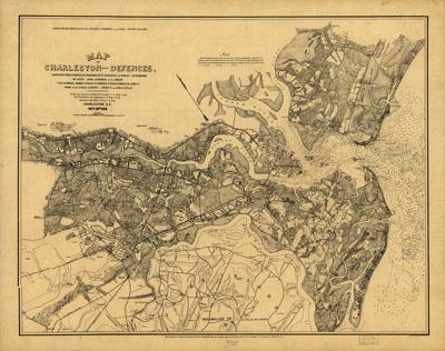
Map of Charleston and its defences Compiled from surveys of portions of St. Andrews and Christ Ch. parishes by Lieut. John Johnson, C.S. Engrs., the harbor, James Id., Folly Id., Morris Id., Sullivans Id., & Long Id., from U.S. Coast Survey, Johns Id., from Mills Atlas. Under the direction of Maj; Wm. H. Echols, C.S. Engr. Corps, by Wm. A. Walker, Draughtsman, C.S. Engr. Corps. Drawn by John R. Key, 2nd. Lieut., C.S. Engr. Charleston, S.C., Nov: 28th, 1863. Endorsed (in facsimile): Approved G. T. Beauregard, Genl. Comdg.; Approved D. B. Harris, Col. & Chef. Engr. Detailed map showing forts and batteries, roads, railroads, towns, houses and names of residents, vegetation, drainage, and soundings in Charleston Harbor and offshore.
SKU: civwar108
Price Starting At: $12.50