1859 Tunis' Map of U.S. and Canada
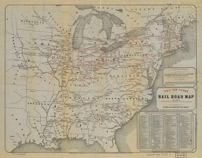
Tunis new colored rail road map of the United States & Canadas; revised and corrected every month. Tunis, W. E.[n.p., 1859] From Tunis' International Rail Road Guide [1859] Map of the eastern United States to about the 96th Meridian. Lower right corner of map has "table showing the length of rail roads, and the page on which their time tables may be found in the guide." "The continious red lines represent rail roads completed. The dotted red lines represent roads projected."
SKU: trans025
Price Starting At: $12.50