1859 Lloyd's American Railroad Map
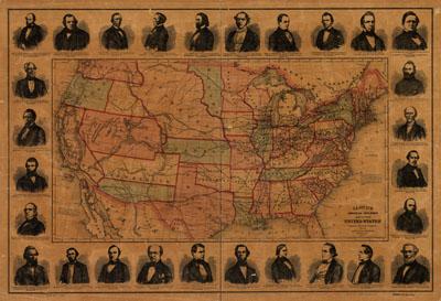
Lloyd's American railroad map of the United States, showing the three proposed roads and the overland mail route to the Pacific, engd. by Rae Smith. Lloyd, James T. [New York], 1859. Relief shown by hachures. Portraits of 28 railroad presidents are reproduced in the border, including: John Robin McDaniel, Jacob Strader, J. D. De Frees, John Caldwell, C. A. Brown, J. Edgar Thompson, Thos. D. Walker, E. Hobbs, R. N. Rice, S. S. L'Hommedieu, Wm. Case, George Palmer, P. A. Hall, Henry C. Lord, A. G. Jaudon, Edwin Robinson, E. H. Gill, W. T. Joynes, J. B. Warring, S. L. Fremont, John L. Helm, John Ross, A. S. Crothers, E. Gest, Erastus Corning, L. M. Hubby, W. H. Clements, John T. Levis, "Entered according to act of Congress in the year 1859 by J.T. Lloyd in the clerk's office of the District Court of the United States ..." "Drawn & engraved at Rae Smith's ... N.Y. from materials furnished to the 36th Congress, March 1859 by G.K. Warren, Lt. U.S. Top. Eng. for the passage of the Pacific Railroad bill.