1855 Williams' Map of U.S. and Canada
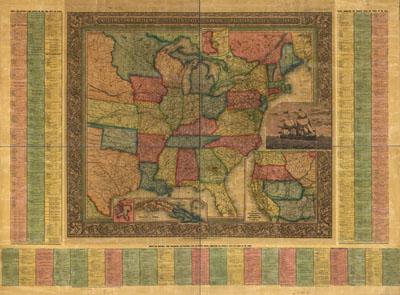
Williams' commercial map of the United States and Canada with railroads, routes, and distances, by W. Williams. Williams, W. (Wellington) Philadelphia, 1855 Includes list of distances between major cities. Insets: City & harbor of Havana.--Map of the Island of Cuba.--Map of the Niagara River and Falls.--Map of California, Oregon, New Mexico, Utah &c. Detailed general map of the eastern half of the United States framed in decorative borders indicating drainage, cities and towns, canals, roads, the railroad network, and indicating the proposed railroad routes to the Pacific Ocean. Railroads in progress are indicated by dashed lines
SKU: trans028
Price Starting At: $12.50