1854 Logansport and Northern Indiana
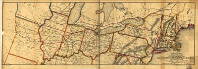
Rail road map accompanying the report an[d] exhibit of the Logansport & Northern Indiana Railroad showing its connections and the through route from St. Louis to New York of which this road forms a part; Logansport, Indiana May 1st 1854; L. S. Nash, Chief Engineer. Nash, L. S. New York, [1854]. Map of the north-central and northeastern United States showing drainage, relief by hachures, place names, and state boundaries. Chartered as the Auburn and Eel River Valley Rail Road on March 8, 1853. Name changed August 3, 1853.
SKU: trans071
Price Starting At: $12.50