1853 Mitchell's Traveller's Guide of U.S.
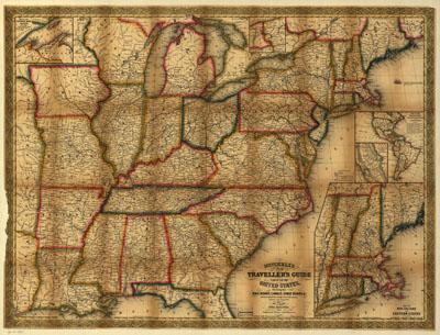
Mitchell's new traveller's guide through the United States, showing the rail roads, canals, stage roads &c. with distances from place to place. Drawn and engraved by Ira S. DrakePhiladelphia, Thomas, Cowperthwait & Co., 1853, c1848. Shows railroads in operation, in progress of construction, and proposed. Insets: Map of the copper mine region.--Vicinity of Niagara Falls.--Map of the maritime and overland routes to California.--Map of the gold and quicksilver district of California.--Map of New England or eastern states. General map of the eastern half of the United States, framed in decorative borders, indicating drainage, state boundaries, major cities and towns, roads, railroads, canals, and distances. [From published bibliography]
SKU: trans038
Price Starting At: $12.50