1840s Railway from Harrisburg to Pittsburgh
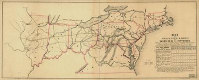
Map of the projected railway from Harrisburg to Pittsburg [sic], with proposed extension to Cleveland, Wooster, Sandusky, Toledo, Cincinnati; Michigan City, Chicago, Galena, Rock Island, St. Louis, &a; in connection with the public works of Pennsylvania, Ohio, Indiana and Illinois. [n.p., 184-] Relief shown by hachures. Covers area between Massachusetts and Virginia and west to the Mississippi River. Shows "finished" and "proposed" railroads. A mileage chart entitled "Rail Road Routes from Seaboard to the Interior" appears at lower right of map. Harrisburg to Pittsburgh Railroad is part of the Pennsylvania Railroad. See entry 517.
SKU: trans040
Price Starting At: $12.50