1829 Territory of Florida
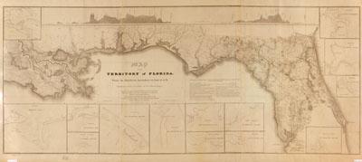
Map of the territory of Florida, from its northern boundary to lat. 27030'N, connected with the delta of the Mississippi : annexed to the report of the Board of Internal Improvement dated Febr. 19th, 1829, relating to the canal contemplated to connect the Atlantic with the Gulf of Mexico and describing the inland navigation parallel to the coast from the Mississippi to the Bay of Espiritu Santo and from St. Mary's Harbour to St. Augustine this map has been compiled under the direction of the Board of Internal Improvement ... ; drawn and compiled by W.H. Swift, lt. artillery. [Washington, D.C.?] : Board of Internal Improvement, 1829. Covers portions of southern states of Florida, Alabama, Mississippi, and Louisiana. Depths shown by soundings. Includes 2 profile charts displaying elevations, area map that extends southward into Gulf of Mexico and Caribbean regions, and 13 insets that show entrances to bays and rivers.