1645 North Pole
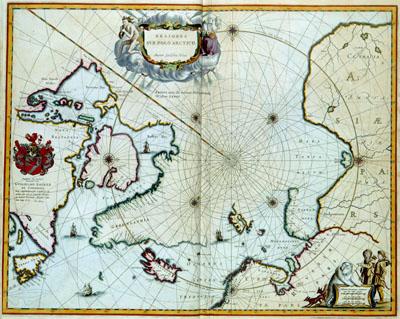
REGIONES SVB POLO ARCTICO, Joan Blaeu (1645)The Northpole formed a mysterious area until far into the 19th century where only few dared to go. Till the end of the 19th century this was thought of as a land mass. From the end of the 16th century knowledge of this enormous icefield grew little by little. In the beginning, it were mainly Dutch and English adventurers and discoverers who visited the pole on their travels in search for a sea route north of Siberia. In this map by Willem Jansz. Blaeu (1571-1638) several discoveries are represented, for instance those by Willem Barendtsz (c. 1550-1597) and the discoveries of the English captains James Hall and Thomas James. Blaeu published the first edition of this map in 1635. This second edition with a dedication to Amsterdam Mayor Willem Backer was published by his son, Joan Blaeu (1598-1673), in 1635.