1640 Uppland, Sweden
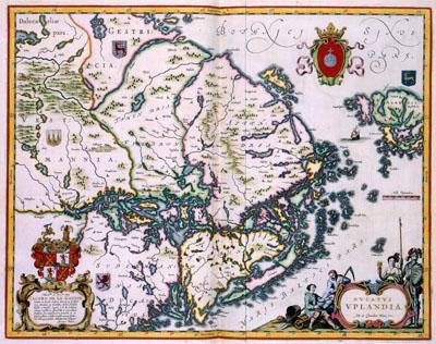
DVCATVS | VPLANDIA Joan and Cornelius Blaeu (1638-1642)After the death of Willem Jansz. Blaeu (c.1571-1638) the publishing house was for some time continued by both his sons Joan (1598-1673) and Cornelis Blaeu (c. 1610-1642). This map about the Swedish duchy of Uppland stems from that period. For this map, the brothers used manuscript maps acquired from the Swedish cartographer Anders Bureus (1571-1661). The map is dedicated to Jacob de la Gardie, supreme judge in Uppland
SKU: 17thcentury282
Price Starting At: $12.50