1638 Southern Russia
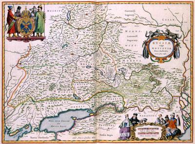
RVSSIAE | vulgo | MOSCOVIA, | Pars Australis, Apud Johan et Cornelium Blaeu (1638)This map of South Russia was published in 1638 by the brothers Joan (1598-1673) and Cornelis Blaeu (1610-1642). The map did not provide accurate information about this part of the Russian Empire, but more accurate data was apparently not available at the time. The image on the map is taken from a travel journal from 1610 by the Amsterdam Mayor Isaac Massa (1586-1643). The data gathered by Massa was used by many Dutch printers in the first half of the 17th century as basis for other maps.
SKU: 17thcentury182
Price Starting At: $12.50