1635 South Africa
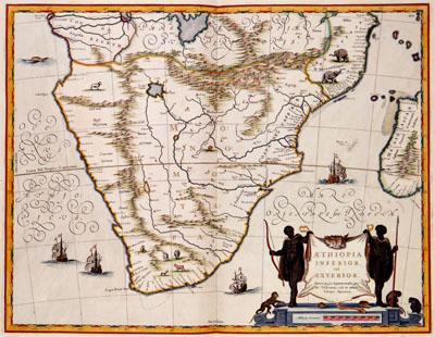
AETHIOPIA | INFERIOR, Willem Jansz. Blaeu (1635)This map by Willem Jansz. Blaeu (c.1571-1638) was used as a model in the 17th century for many maps of South-Africa. The map is partly based on the map of the kingdom of Prester John by Abraham Ortelius (1527-1598) from 1573. According to old legends there was a christian kingdom somewhere in the unexplored inlands of Afric. The east coast has been represented relatively accurately for which Blaeu probable made use of Portugese sources. The two great lakes south of the equator were represented based on descriptions by Ptolemeus from the second century. The lakes were believed to be the sources of the River Nile.
SKU: 17thcentury236
Price Starting At: $12.50