1635 Rhine River
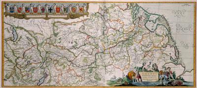
RHENVS | Fluviorum Europae celeberrimus | cum MOSA MOSELLA, et | reliquis in illum se exonerantibus | fluminibus, Nicolaas Visscher (1862)This map, showing the complete area of the river Rhine, was published by the publishing company of Nicolaas Visscher. The engraver has depicted the coats of arms of all the territories along the river from its source to the North Sea. This map was originally published by Willem Jansz. Blaeu (1571-1638) in 1635.
SKU: 17thcentury085
Price Starting At: $12.50