1630 Bermuda Islands
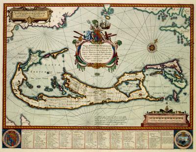
Mappa AESIVARVM Insularum | alias BARMVDAS dictarum, ad Ostia | Mexicani aestuarij jacentium in latitudine Gra- | duum 32 Minutorium 25 Ab Anglia, Londino | Scilicet versus | Libonotum 3300 Miliaribus | Anglicanis, et a Roanoack (qui locus est | in Virginia) versus Euronotum 500 Mill. | accurate descriptio, Willem Jansz. Blaeu (1630)This map of the Bermudas was published by Willem Jansz. Blaeu (1571-1638) in 1630. Blaeu copied the map after an example from 1626 by the English cartographer John Speed (1552-1629), while Speed had used a map by the English surveyor Richard Norwood (1590-1675) from 1622 as his source. The central theme on the map is the distribution of landownerships on the islands. The register along the lower part of the map explaines the distribution of lands and the names of owners.